SV600 Unmanned Surface Vessel
Hydrographic surveys require precision, performance and equipment capable of operating in demanding environments. The SV600 has been engineered to meet these expectations by combining advanced navigation features, multi sensor compatibility and intuitive mission control.
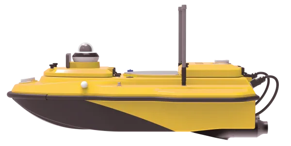
A Versatile Platform for Hydrographic Missions
The SV600 is an advanced Unmanned Surface Vessel designed specifically for hydrographic and environmental surveys. It supports full remote control and integrates adaptive water flow straight-line navigation and hovering technology to stabilize operations and improve measurement accuracy.
Its dual moon pool design enables the simultaneous deployment of multiple payloads. This allows operators to mount ADCPs, single beam echo sounders, side scan sonars, pipeline detectors and compact multi beam echo sounders on the same platform.
Mission preparation is fast. Thanks to its rapid installation structure, teams can transition between survey modes without interrupting workflow, ensuring high efficiency across varied measurement operations.
Learn more
Software
SNPilot
SNPilot is a Linux-based ground control software designed to manage and monitor USV operations. Users can customise missions, manually control navigation, track progress and input coordinate systems.
The system supports automatic return in case of low power or signal loss, with the option to define a specific return point. It displays trajectory, sounding data, waveform and video in real time. Data can be stored locally on the ground device or directly in the vessel for later analysis.
EchoSurvey
EchoSurvey is a post processing software used for detailed analysis of collected data. It supports data replay, waveform depth overlay, tide correction, data delay correction, attitude correction and coordinate parameter conversion.
The software allows resampling based on time or distance and offers custom export formats to simplify downstream processing. Depth values can be displayed with different color scales and the interface provides rollback and undo functions to facilitate quality control.
Related Products
SV600 USV
The SV600 integrates seamlessly with ComNav’s ecosystem of GNSS receivers and hydrographic tools.
Explore All Marine Survey Solutions
Looking for complete equipment for hydrographic and environmental missions
Discover ComNav Technology receivers, antennas and specialized USVs designed to support accurate and reliable water surface surveys.
Our team can help you define the optimal configuration for your workflow.